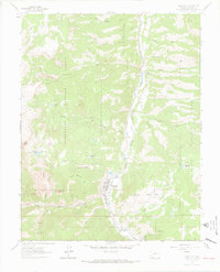
1963 Map of Lake City
USGS Topo · Published 1970About this map
Lake City sits at the junction of Henson Creek and the Lake Fork Gunnison, serving as a high-altitude center for the San Juan mining district during the early 1960s. The landscape is defined by the heavy presence of hard-rock mining history, with a concentration of notable operations including the Hidden Treasure Mine, Golden Wonder Mine, and Belle of the West Mine scattered across the surrounding slopes. These workings follow the steep drainages of Wade Gulch and Slaughterhouse Gulch, marking the legacy of the region's late-19th-century silver and lead boom.
Find a feature on this map
60 named features on this map. Tap any name to fly to it.
Don’t see what you’re looking for? This feature index may not catch every label — zoom into the map to look around manually.
Map Details
Editions of this 1963 Lake City Map
3 editions found
Other maps of this area

1903 · Lake City
USGS Topo · 1:62,500

1905 · Lake City
USGS Topo · 1:62,500

1905 · San Cristobal
USGS Topo · 1:125,000

1907 · San Cristobal
USGS Topo · 1:125,000

1908 · Uncompahgre
USGS Topo · 1:125,000

1911 · Uncompahgre
USGS Topo · 1:125,000

1945 · Durango
USGS Topo · 1:250,000

1953 · Durango
USGS Topo · 1:250,000

1954 · Durango
USGS Topo · 1:250,000

1956 · Montrose
USGS Topo · 1:250,000