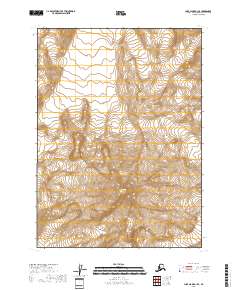
2018 Map of Lake Clark A-1 SE
USGS Topo · Published 2018About this map
Iliamna Volcano dominates the southern portion of this landscape within Lake Clark National Park, representing one of the many active volcanic peaks of the Aleutian Range. This 2018 survey documents a region of high-altitude ice and glacial flow, where the massif is surrounded by several prominent named glaciers including the Johnson Glacier, Tuxedni Glacier, and Double Glacier. The terrain character is defined by extreme relief, with Mt Nick standing as a significant landmark above the ice fields. Further east and north, the ice-carved drainage patterns continue through Tongue, Lateral, and Umbrella Glacier. This document serves as a modern record of glacial extent and alpine topography in a protected wilderness area, capturing the complex network of ice and rock that shapes the Kenai Peninsula’s western highlands.
Find a feature on this map
14 named features on this map. Tap any name to fly to it.
Don’t see what you’re looking for? This feature index may not catch every label — zoom into the map to look around manually.
Map Details
Editions of this 2018 Lake Clark A-1 SE Map
This is the sole edition of this map. No revisions or reprints were ever made.
Other maps of this area

1944 · Kenai
USGS Topo · 1:250,000

1946 · Lake Clark
USGS Topo · 1:250,000

1950 · Kenai
USGS Topo · 1:250,000

1951 · Lake Clark
USGS Topo · 1:250,000

1951 · Seldovia
USGS Topo · 1:250,000

1952 · Iliamna
USGS Topo · 1:250,000

1957 · Iliamna
USGS Topo · 1:250,000

1958 · Iliamna D-1
USGS Topo · 1:63,360
1958 · Seldovia D-8
USGS Topo · 1:63,360

1958 · Lake Clark A-1
USGS Topo · 1:63,360