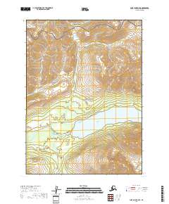
2018 Map of Lake Clark A-4 SE
USGS Topo · Published 2018About this map
Upper Tazimina Lake and the Tazimina River dominate the central basin of this Alaskan interior landscape. The 2018 survey reveals a sharp administrative and topographical divide between the Lake Clark National Park to the north and the Lake Clark National Preserve in the south. High-elevation contours define the northern boundary, while the lake system provides a lower-elevation corridor through the terrain. The map's detailed hydrology and Public Land Survey System lines, including t1s r29w and t2s r28w, document the formal partitioning of this wilderness area within the Lake and Peninsula Borough. This documentation is essential for understanding the modern conservation boundaries of the region's protected lands.
Find a feature on this map
8 named features on this map. Tap any name to fly to it.
Don’t see what you’re looking for? This feature index may not catch every label — zoom into the map to look around manually.
Map Details
Editions of this 2018 Lake Clark A-4 SE Map
This is the sole edition of this map. No revisions or reprints were ever made.
Other maps of this area

1946 · Lake Clark
USGS Topo · 1:250,000

1951 · Lake Clark
USGS Topo · 1:250,000

1952 · Iliamna
USGS Topo · 1:250,000

1954 · Lake Clark A-3
USGS Topo · 1:63,360

1954 · Iliamna D-3
USGS Topo · 1:63,360

1954 · Iliamna D-4
USGS Topo · 1:63,360

1954 · Lake Clark A-4
USGS Topo · 1:63,360

1957 · Iliamna
USGS Topo · 1:250,000

1958 · Lake Clark
USGS Topo · 1:250,000
2018 · Lake Clark A-4 SW
USGS Topo · 1:25,000