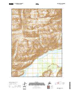
2018 Map of Lake Clark B-1 SE
USGS Topo · Published 2018About this map
Lake Clark National Park dominates this 2018 survey, capturing the massive ice-and-water systems that define the Aleutian Range on the Kenai Peninsula. The landscape is shaped by the descent of the Tuxedni Glacier into the broad basin of the Tuxedni River, illustrating the dynamic interplay of glacial melt and river morphology. This data provides a detailed record of the drainage patterns within the protected federal lands, where the absence of roads or permanent settlements highlights the wilderness character of the region. Topographic contours reveal the steep transitions from high alpine ice fields down to the river delta, a crucial record for researchers monitoring landscape changes in this corner of Alaska.
Find a feature on this map
10 named features on this map. Tap any name to fly to it.
Don’t see what you’re looking for? This feature index may not catch every label — zoom into the map to look around manually.
Map Details
Editions of this 2018 Lake Clark B-1 SE Map
This is the sole edition of this map. No revisions or reprints were ever made.
Other maps of this area

1944 · Kenai
USGS Topo · 1:250,000

1946 · Lake Clark
USGS Topo · 1:250,000

1950 · Kenai
USGS Topo · 1:250,000

1951 · Lake Clark
USGS Topo · 1:250,000

1958 · Lake Clark A-1
USGS Topo · 1:63,360

1958 · Lake Clark B-1
USGS Topo · 1:63,360
1958 · Kenai A-8
USGS Topo · 1:63,360

1958 · Kenai B-8
USGS Topo · 1:63,360

1958 · Lake Clark
USGS Topo · 1:250,000

1958 · Kenai
USGS Topo · 1:250,000