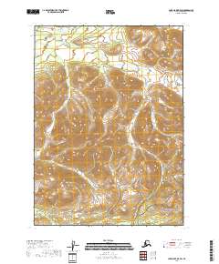
2018 Map of Lake Clark B-5 SW
USGS Topo · Published 2018About this map
Koksetna River meanders across the northern reaches of this landscape, its waters cutting through the high elevation terrain characteristic of the Alaska Range. Much of the southeastern portion of the map is designated as part of the Lake Clark National Preserve, protecting a wilderness area where the mountain slopes descend toward the lowlands. The survey shows the complex topographic contours of the region, including the survey lines for t3n r32w and t2n r32w. The absence of roads or established settlements emphasizes the remote nature of this part of the Lake and Peninsula Borough during the early 21st century.
Find a feature on this map
6 named features on this map. Tap any name to fly to it.
Don’t see what you’re looking for? This feature index may not catch every label — zoom into the map to look around manually.
Map Details
Editions of this 2018 Lake Clark B-5 SW Map
This is the sole edition of this map. No revisions or reprints were ever made.
Other maps of this area

1946 · Lake Clark
USGS Topo · 1:250,000

1951 · Lake Clark
USGS Topo · 1:250,000

1954 · Lake Clark A-6
USGS Topo · 1:63,360

1954 · Lake Clark B-5
USGS Topo · 1:63,360

1954 · Lake Clark A-5
USGS Topo · 1:63,360

1954 · Lake Clark B-6
USGS Topo · 1:63,360

1958 · Lake Clark
USGS Topo · 1:250,000
2018 · Lake Clark B-5 NW
USGS Topo · 1:25,000
2018 · Lake Clark A-5 NE
USGS Topo · 1:25,000
2018 · Lake Clark A-5 NW
USGS Topo · 1:25,000