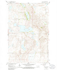
1961 Map of Lake Coe
USGS Topo · Published 1986About this map
Lake Coe and a chain of surrounding prairie lakes dominate this Eddy County landscape during the early 1960s. The area is defined by its glacial topography, featuring numerous scattered depressions and water bodies including Cherry Lake, Medicine Lake, and Ninemile Lake. The map reveals a rural educational system centered on small, numbered district facilities like School No 9 and School No 8, which served the farming families within the townships of Lake Washington, Colvin, and Paradise. A single Landing Field situated near South Washington Lake provides a glimpse into local aviation of the era, while several Gravel Pits suggest the localized extraction of glacial deposits for road building. This survey, completed as part of the Missouri River Basin development program, captures the intricate network of fence and field lines that organized the North Dakota prairie before the widespread consolidation of modern agricultural tracts.
Find a feature on this map
19 named features on this map. Tap any name to fly to it.
Don’t see what you’re looking for? This feature index may not catch every label — zoom into the map to look around manually.
Map Details
Editions of this 1961 Lake Coe Map
2 editions found
Other maps of this area

1928 · Tokio
USGS Topo · 1:62,500

1930 · Hamar
USGS Topo · 1:62,500

1931 · Tokio
USGS Topo · 1:62,500

1944 · Brantford
USGS Topo · 1:62,500

1946 · Brantford
USGS Topo · 1:62,500

1949 · Grace City
USGS Topo · 1:24,000

1950 · Grace City
USGS Topo · 1:24,000

1950 · Brantford NE
USGS Topo · 1:24,000
1951 · Horseshoe Lake
USGS Topo · 1:24,000
1951 · Tokio
USGS Topo · 1:62,500