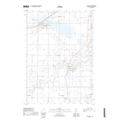
2019 Map of Lake Crystal
USGS Topo · Published 2019About this map
Lake Crystal serves as the focal point of this Blue Earth County landscape, where the namesake settlement is defined by its proximity to Lily Lake and Loon Lake. The town’s grid, featuring streets like W Humphrey St and E Prince St, transitions into a high-density wetland and lake district. To the southeast, the village of Garden City sits near a bend in the Watonwan River, a waterway that carves a winding path across the southern half of the quadrangle before approaching the Blue Earth River at the eastern margin.
Find a feature on this map
53 named features on this map. Tap any name to fly to it.
Don’t see what you’re looking for? This feature index may not catch every label — zoom into the map to look around manually.
Map Details
Editions of this 2019 Lake Crystal Map
This is the sole edition of this map. No revisions or reprints were ever made.
Other maps of this area

1951 · Mankato West
USGS Topo · 1:62,500

1953 · New Ulm
USGS Topo · 1:250,000

1954 · Fairmont
USGS Topo · 1:250,000

1957 · New Ulm
USGS Topo · 1:250,000

1958 · New Ulm
USGS Topo · 1:250,000

1958 · Fairmont
USGS Topo · 1:250,000

1965 · Perth
USGS Topo · 1:24,000

1965 · Cambria
USGS Topo · 1:24,000

1967 · New Ulm
USGS Topo · 1:250,000

1967 · Willow Creek
USGS Topo · 1:24,000