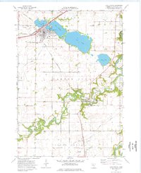
1974 Map of Lake Crystal
USGS Topo · Published 1976About this map
Lake Crystal serves as the primary hub of this south-central Minnesota landscape, situated alongside the Lily Lake and Lake Crystal shorelines. The town's layout reflects its reliance on the Chicago and North Western railroad, which cuts through the northern section of the quadrangle. To the south, the meandering Watonwan River defines the terrain, flowing toward its confluence with the Blue Earth River at the eastern edge.
Find a feature on this map
26 named features on this map. Tap any name to fly to it.
Don’t see what you’re looking for? This feature index may not catch every label — zoom into the map to look around manually.
Map Details
Editions of this 1974 Lake Crystal Map
This is the sole edition of this map. No revisions or reprints were ever made.
Other maps of this area

1951 · Mankato West
USGS Topo · 1:62,500

1953 · New Ulm
USGS Topo · 1:250,000

1954 · Fairmont
USGS Topo · 1:250,000

1957 · New Ulm
USGS Topo · 1:250,000

1958 · New Ulm
USGS Topo · 1:250,000

1958 · Fairmont
USGS Topo · 1:250,000

1965 · Perth
USGS Topo · 1:24,000

1965 · Cambria
USGS Topo · 1:24,000

1967 · New Ulm
USGS Topo · 1:250,000

1967 · Willow Creek
USGS Topo · 1:24,000