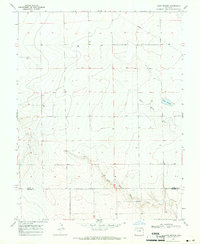
1968 Map of Lake Devore
USGS Topo · Published 1971About this map
West Wild Horse Creek carves a distinct path through the southeastern High Plains in this late 1960s survey. The landscape is characterized by its wide drainage basins and sparse industrial development, centered primarily around water management and transit. Lake Devore stands as the primary water body in a region where several marked wells indicate the reliance on groundwater for the local agricultural or ranching economy. A prominent Pipeline cuts diagonally across the northern sections, while a lone Water Tank in the west serves as a rare vertical landmark. The transition between Kiowa County and Prowers County is clearly delineated in the south, reflecting the administrative boundary lines that shaped this portion of Colorado.
Find a feature on this map
6 named features on this map. Tap any name to fly to it.
Don’t see what you’re looking for? This feature index may not catch every label — zoom into the map to look around manually.
Map Details
Editions of this 1968 Lake Devore Map
This is the sole edition of this map. No revisions or reprints were ever made.
Other maps of this area

1890 · Granada
USGS Topo · 1:125,000

1892 · Granada
USGS Topo · 1:125,000

1894 · Granada
USGS Topo · 1:125,000

1954 · Lamar
USGS Topo · 1:250,000

1955 · Holly NE
USGS Topo · 1:24,000

1955 · Granada NE
USGS Topo · 1:24,000
1955 · Holly NW
USGS Topo · 1:24,000

1958 · Lamar
USGS Topo · 1:250,000

1968 · Stuart
USGS Topo · 1:24,000

1968 · Sheridan Lake
USGS Topo · 1:24,000