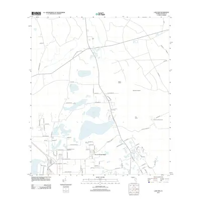
2012 Map of Lake Dias
USGS Topo · Published 2012About this map
De Leon Springs Heights serves as the primary residential hub in this interior Volusia County landscape, situated near the famous Ponce de Leon Springs and Spring Garden Lake. The geography is defined by a dense network of water bodies, including the centrally located Lake Dias and its smaller neighbors like Lake Winona and Lake Odom. The presence of several historic burial grounds, such as Lake Dias Cem, Clifton Cem, and the Mount Olive Primitive Baptist Cem, provides valuable reference points for genealogists and local historians tracking family lineages in the region. North of the residential areas, the terrain transitions into a mosaic of wetlands and named landforms like Banks Island and Pine Island, navigated by rural corridors such as Old Perkins Hwy. This 2012 survey illustrates the mix of recreational camps like Camp Winona, small-scale aviation at Lafayette Landings Airport, and the preservation of landmarks like the De Leon Lookout Tower.
Find a feature on this map
99 named features on this map. Tap any name to fly to it.
Don’t see what you’re looking for? This feature index may not catch every label — zoom into the map to look around manually.
Map Details
Editions of this 2012 Lake Dias Map
This is the sole edition of this map. No revisions or reprints were ever made.
Other maps of this area

1937 · Ormond
USGS Topo · 1:48,000

1944 · Ormond
USGS Topo · 1:62,500

1954 · Daytona Beach
USGS Topo · 1:250,000

1956 · Favoretta
USGS Topo · 1:24,000

1958 · Daytona Beach
USGS Topo · 1:250,000

1962 · Daytona Beach NW
USGS Topo · 1:24,000

1962 · Daytona Beach SW
USGS Topo · 1:24,000

1962 · Lake Woodruff
USGS Topo · 1:24,000

1964 · Daytona Beach
USGS Topo · 1:250,000
1964 · De Land
USGS Topo · 1:24,000