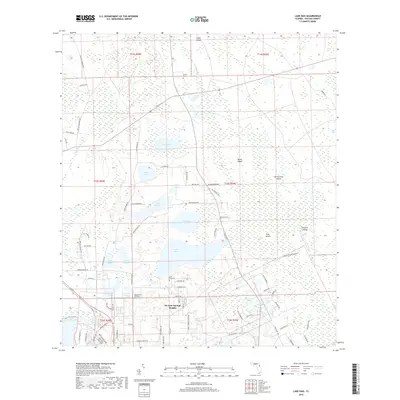
2018 Map of Lake Dias
USGS Topo · Published 2018About this map
Ponce de Leon Springs anchors the southwest corner of this Volusia County landscape, where the sandy ridges of central Florida meet the wetlands of the St. Johns River basin. The area is defined by a dense network of freshwater bodies, including the large Lake Dias and Lake Winona, surrounded by significant terrain features like Heart Island and the swampy expanse of Tiger Bay. Settlement is concentrated in De Leon Springs Heights and the small airfield community at Lafayette Landings. Genealogists will find several burial sites recorded here, including Clifton Cem, Lake Dias Cem, and the Mount Olive Primitive Baptist Cem. The drainage pattern of Little Haw Cr and Deep Cr illustrates the hydrological complexity of this region before it gives way to the deeper hammocks and islands such as Banks Island and the descriptively named Burned Out Island.
Find a feature on this map
88 named features on this map. Tap any name to fly to it.
Don’t see what you’re looking for? This feature index may not catch every label — zoom into the map to look around manually.
Map Details
Editions of this 2018 Lake Dias Map
This is the sole edition of this map. No revisions or reprints were ever made.
Other maps of this area

1937 · Ormond
USGS Topo · 1:48,000

1944 · Ormond
USGS Topo · 1:62,500

1954 · Daytona Beach
USGS Topo · 1:250,000

1956 · Favoretta
USGS Topo · 1:24,000

1958 · Daytona Beach
USGS Topo · 1:250,000

1962 · Daytona Beach NW
USGS Topo · 1:24,000

1962 · Daytona Beach SW
USGS Topo · 1:24,000

1962 · Lake Woodruff
USGS Topo · 1:24,000

1964 · Daytona Beach
USGS Topo · 1:250,000
1964 · De Land
USGS Topo · 1:24,000