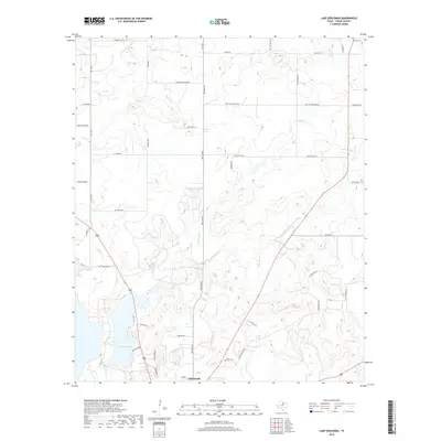
2019 Map of Lake Eddleman
USGS Topo · Published 2019About this map
Lake Eddleman serves as a focal point in the northern outskirts of Graham, where the landscape is defined by the winding paths of Flint Creek and Turtle Hole Creek. The terrain is marked by family-named routes and local landmarks such as Indian Mound Road and Rocky Mound Road, reflecting a history of small-scale agriculture and rural settlement patterns. In the northeast, the Loving Cemetery provides a link to the community's genealogical past near the junction of several local roads.
Find a feature on this map
43 named features on this map. Tap any name to fly to it.
Don’t see what you’re looking for? This feature index may not catch every label — zoom into the map to look around manually.
Map Details
Editions of this 2019 Lake Eddleman Map
This is the sole edition of this map. No revisions or reprints were ever made.
Other maps of this area

1924 · Graham 4-d
USGS Topo · 1:48,000

1925 · Graham 4-c
USGS Topo · 1:48,000

1927 · Graham
USGS Topo · 1:62,500

1954 · Wichita Falls
USGS Topo · 1:250,000

1958 · Wichita Falls
USGS Topo · 1:250,000

1964 · Newcastle
USGS Topo · 1:24,000

1964 · True
USGS Topo · 1:24,000

1964 · Loving
USGS Topo · 1:24,000

1964 · Bryson
USGS Topo · 1:24,000

1964 · Lake Eddleman
USGS Topo · 1:24,000