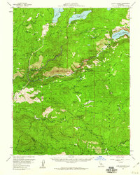
1956 Map of Lake Eleanor
USGS Topo · Published 1960About this map
The high Sierra water infrastructure of the late 1950s dominates this landscape, where the Tuolumne River and its forks are harnessed for utility and power. The Hetch Hetchy Reservoir and Lake Eleanor Reservoir are central features, connected by the subsurface Hetch Hetchy Aqueduct (Tunnel) and supported by the Early Intake Powerhouse. This era represents a peak in the management of the watershed, with the newly mapped Cherry Lake expanding the region's reservoir capacity.
Find a feature on this map
82 named features on this map. Tap any name to fly to it.
Don’t see what you’re looking for? This feature index may not catch every label — zoom into the map to look around manually.
Map Details
Editions of this 1956 Lake Eleanor Map
3 editions found

Other maps of this area

1891 · Big Trees
USGS Topo · 1:125,000

1893 · Sonora
USGS Topo · 1:125,000

1894 · Big Trees
USGS Topo · 1:125,000

1896 · Dardanelles
USGS Topo · 1:125,000

1896 · Sonora
USGS Topo · 1:125,000

1897 · Sonora
USGS Topo · 1:125,000

1897 · Big Trees
USGS Topo · 1:125,000

1897 · Yosemite
USGS Topo · 1:125,000

1898 · Dardanelles
USGS Topo · 1:125,000

1898 · Sonora
USGS Topo · 1:125,000