1956 Map of Lake Eleanor
USGS Topo · Published 1965About this map
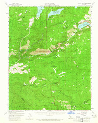
Yosemite National Park and Stanislaus National Forest converge on this mid-century survey, dominated by the massive water engineering of the Hetch Hetchy Reservoir and Lake Eleanor Reservoir. The landscape is defined by the steep drainage of the Tuolumne River and its multiple forks, which are harnessed by the Hetch Hetchy Aqueduct. Human presence in this wilderness is marked by early high-country outposts like Mather, Evergreen Lodge, and the Five Star Mine. Historic travel routes, including the Tioga Road and the Old Big Oak Flat Road, trace the topography across Crocker Ridge toward the Big Creek Basin. Scattered throughout the forest are numerous specialized camps and ranger stations, such as Columbia Camp, Tuolumne Camp, and the Lake Eleanor Ranger Station, reflecting the area's dual roles in resource management and recreation.
Find a feature on this map
72 named features on this map. Tap any name to fly to it.
Don’t see what you’re looking for? This feature index may not catch every label — zoom into the map to look around manually.
Map Details
Editions of this 1956 Lake Eleanor Map
3 editions found

Other maps of this area

1891 · Big Trees
USGS Topo · 1:125,000

1893 · Sonora
USGS Topo · 1:125,000

1894 · Big Trees
USGS Topo · 1:125,000

1896 · Dardanelles
USGS Topo · 1:125,000

1896 · Sonora
USGS Topo · 1:125,000

1897 · Sonora
USGS Topo · 1:125,000

1897 · Big Trees
USGS Topo · 1:125,000

1897 · Yosemite
USGS Topo · 1:125,000

1898 · Dardanelles
USGS Topo · 1:125,000

1898 · Sonora
USGS Topo · 1:125,000