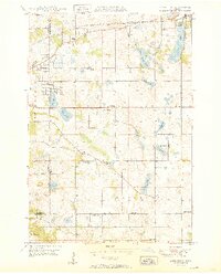
1950 Map of Lake Elmo
USGS Topo · Published 1950About this map
The Lake Elmo area in the mid-century shows a transitional landscape where established lakeside settlements and a dense network of rural school districts meet the expanding reach of the Chicago and North Western railroad. The map preserves the specific locations of numerous one-room schoolhouses that once served this portion of Washington County, including School No 13, Gillie Sch, and Carver Sch. While the village of Lake Elmo is a primary hub, smaller points like Midvale and Oakbury reflect the older hamlet-based structure of the township. In the southern half, the terrain of Woodbury is dotted with landmarks like the Woodbury Ch and several named family-linked schools such as Schilling Sch and Salem Sch. The map's hydrography is particularly prominent, featuring a chain of water bodies from Eagle Point Lake down to Carver Lake, providing a clear view of the natural drainage and wetland patterns before significant suburban development.
Find a feature on this map
31 named features on this map. Tap any name to fly to it.
Don’t see what you’re looking for? This feature index may not catch every label — zoom into the map to look around manually.
Map Details
Editions of this 1950 Lake Elmo Map
2 editions found
Other maps of this area

1896 · St. Paul
USGS Topo · 1:62,500

1902 · White Bear
USGS Topo · 1:62,500

1946 · Hudson
USGS Topo · 1:62,500

1948 · Stillwater
USGS Topo · 1:62,500

1949 · Hudson
USGS Topo · 1:62,500

1949 · Stillwater
USGS Topo · 1:62,500

1949 · Lake Elmo
USGS Topo · 1:24,000
1949 · Hudson
USGS Topo · 1:24,000

1950 · Lake Elmo
USGS Topo · 1:24,000
1950 · Hudson
USGS Topo · 1:24,000