
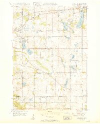
1950 Map of Lake Elmo
USGS Topo · Published 1950About this map
Lake Elmo serves as the focal point of this 1950 survey, anchored by its namesake settlement and the Chicago and North Western railroad line. The landscape reflects a transition from rural townships like Oakdale and Woodbury into a more developed suburban pattern, particularly near the Ramsey and Washington county line. Numerous small district schools, including Schilling Sch, Salem Sch, and Gillie Sch, are scattered throughout the countryside, documenting the localized educational infrastructure of mid-century Minnesota.
Find a feature on this map
34 named features on this map. Tap any name to fly to it.
Don’t see what you’re looking for? This feature index may not catch every label — zoom into the map to look around manually.
Map Details
Editions of this 1950 Lake Elmo Map
2 editions found
Other maps of this area

1896 · St. Paul
USGS Topo · 1:62,500

1902 · White Bear
USGS Topo · 1:62,500

1946 · Hudson
USGS Topo · 1:62,500

1948 · Stillwater
USGS Topo · 1:62,500

1949 · Hudson
USGS Topo · 1:62,500

1949 · Stillwater
USGS Topo · 1:62,500

1949 · Lake Elmo
USGS Topo · 1:24,000

1949 · Hudson
USGS Topo · 1:24,000

1950 · Hudson
USGS Topo · 1:24,000

1950 · St Paul Park
USGS Topo · 1:24,000