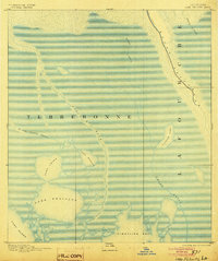
1894 Map of Lake Felicity
USGS Topo · Published 1904About this map
Bayou Lafourche defines the eastern boundary of this coastal landscape, flowing toward the Gulf through a complex network of marshlands and open water. Surveyed in 1891, the map captures the transition between Terrebonne and Lafourche parishes, where the land fragmentizes into major water bodies like Lake Felicity and Catfish Lake. The intricate hydrology of the region is evident in the winding courses of Bayou Du Chien and St. Jean Charles Bayou, which serve as primary corridors through the low-lying terrain. To the south, the land yields entirely to Timbalier Bay, illustrating the expansive coastal marsh and ridge system before the era of significant modern coastal erosion. Small, unnamed settlements and landings along the bayous suggest a local economy deeply tied to the tides and the river's distributaries.
Find a feature on this map
14 named features on this map. Tap any name to fly to it.
Don’t see what you’re looking for? This feature index may not catch every label — zoom into the map to look around manually.
Map Details
Editions of this 1894 Lake Felicity Map
3 editions found
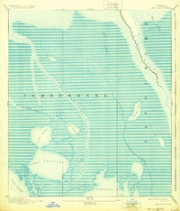
Other maps of this area

1892 · Barataria
USGS Topo · 1:62,500

1892 · Cheniere Caminada
USGS Topo · 1:62,500

1892 · Cut-Off
USGS Topo · 1:62,500

1892 · Houma
USGS Topo · 1:62,500

1892 · Creole
USGS Topo · 1:62,500

1894 · Timbalier
USGS Topo · 1:62,500

1894 · Lake Felicity
USGS Topo · 1:62,500

1894 · Dulac
USGS Topo · 1:62,500

1932 · Houma SE
USGS Topo · 1:31,680

1935 · Bourbeux
USGS Topo · 1:31,680