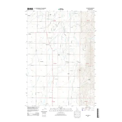
2013 Map of Lake Fork
USGS Topo · Published 2013About this map
Agricultural water management and rural aviation define this Idaho landscape south of McCall. The drainage of Lake Fork and Boulder Cr is meticulously partitioned by a network of man-made waterways including the Lake Irrigation District Canal, Cruzen Ditch, and Westside Lake Fork Ditch. These irrigation features supported the small settlements of Norwood, Spink, and Lake Fork as they developed amidst the valley's meadows. A trio of private airstrips—Flying A Ranch Airport, Splan Airport, and Bear Air Airport—indicates the importance of regional flight in this mountainous terrain. Cultural history is anchored by the Finn Cem and Spink Cem, which serve as vital markers for genealogical research in the area. To the east, the terrain rises toward Timber Ridge and Bear Gulch, while the northern reach of Lake Cascade begins to appear in the south, illustrating the transition from managed ranchland to larger water storage systems.
Find a feature on this map
101 named features on this map. Tap any name to fly to it.
Don’t see what you’re looking for? This feature index may not catch every label — zoom into the map to look around manually.
Map Details
Editions of this 2013 Lake Fork Map
This is the sole edition of this map. No revisions or reprints were ever made.
Other maps of this area

1911 · Meadows
USGS Topo · 1:125,000

1954 · Gold Fork
USGS Topo · 1:62,500

1954 · Cascade
USGS Topo · 1:62,500

1955 · Baker
USGS Topo · 1:250,000

1957 · Challis
USGS Topo · 1:250,000

1959 · Baker
USGS Topo · 1:250,000

1960 · Challis
USGS Topo · 1:250,000

1963 · Challis
USGS Topo · 1:250,000
1973 · Meadows
USGS Topo · 1:24,000
1973 · No Business Mtn
USGS Topo · 1:24,000