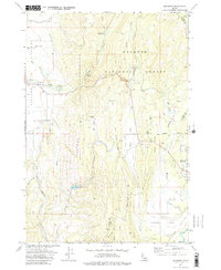
1973 Map of Meadows
USGS Topo · Published 1976About this map
Meadows Valley and the high country of the Payette National Forest define this western Idaho landscape during the early 1970s. The settlement of Meadows sits at the junction of several drainage systems, including the Threemile Creek and Little Goose Creek headwaters. A significant historical element is the presence of the Old Railroad Grade, which winds through the central and southern portions of the map, tracing the legacy of timber or transport lines through the mountain passes.
Find a feature on this map
30 named features on this map. Tap any name to fly to it.
Don’t see what you’re looking for? This feature index may not catch every label — zoom into the map to look around manually.
Map Details
Editions of this 1973 Meadows Map
2 editions found
Other maps of this area

1911 · Meadows
USGS Topo · 1:125,000

1938 · Riggins
USGS Topo · 1:96,000

1945 · Riggins
USGS Topo · 1:125,000

1954 · New Meadows
USGS Topo · 1:62,500

1955 · Baker
USGS Topo · 1:250,000

1955 · Grangeville
USGS Topo · 1:250,000

1959 · Baker
USGS Topo · 1:250,000

1959 · Grangeville
USGS Topo · 1:250,000

1963 · Bally Mountain
USGS Topo · 1:24,000

1963 · Granite Lake
USGS Topo · 1:24,000