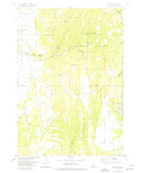
1973 Map of Meadows
USGS Topo · Published 1976About this map
Meadows Valley Cem and the settlement of Meadows stand on the western edge of a high mountain basin, where the landscape transitions from the open Meadows Valley into the timbered reaches of the Payette National Forest. This 1973 survey captures the area’s outdoor and historical character, featuring Packer Johns Cabin State Park and the rugged topography of Red Ridge and Meadows Hill. An Old Railroad Grade winds through the central terrain near Moorehead Flat, tracing a path once vital to the region's timber and transport economy. To the east, the edge of Mc Call is visible near the Adams and Valley County line, situated above the drainage of Williams Creek. The map documents a network of water features including Fish Lake and Little Goose Creek, alongside specialized sites like the Thorn Creek Fire Camp and a Landing Strip near Rock Flat Creek.
Find a feature on this map
39 named features on this map. Tap any name to fly to it.
Don’t see what you’re looking for? This feature index may not catch every label — zoom into the map to look around manually.
Map Details
Editions of this 1973 Meadows Map
2 editions found
Other maps of this area

1911 · Meadows
USGS Topo · 1:125,000

1938 · Riggins
USGS Topo · 1:96,000

1945 · Riggins
USGS Topo · 1:125,000

1954 · New Meadows
USGS Topo · 1:62,500

1955 · Baker
USGS Topo · 1:250,000

1955 · Grangeville
USGS Topo · 1:250,000

1959 · Baker
USGS Topo · 1:250,000

1959 · Grangeville
USGS Topo · 1:250,000

1963 · Bally Mountain
USGS Topo · 1:24,000

1963 · Granite Lake
USGS Topo · 1:24,000