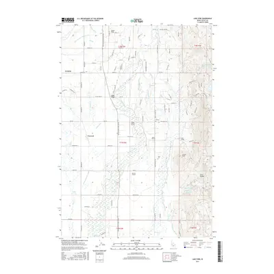
2017 Map of Lake Fork
USGS Topo · Published 2017About this map
Lake Fork and Norwood anchor this Valley County landscape, a region defined by an intricate network of irrigation and aviation. The Payette River Scenic Byway cuts through the valley floor, connecting agricultural tracts that rely on the Spink Barker Ditch, Mahala Ditch, and Cruzen Ditch to manage the waters of Boulder Cr and the Lake Fork river. This 2017 survey reveals a particular concentration of private airstrips, including the Flying A Ranch Airport, Splan Airport, and Bear Air Airport, which reflect the modern logistical character of this mountain-fringed basin. For genealogists and local historians, the presence of the Finn Cem and Spink Cem provides specific points for family research. To the east, the terrain rises into the foothills where the Lower Jug Cr Reservoir and Melton Reservoir are found near Bear Gulch, while the southern edge of the map reaches the northern reaches of Lake Cascade.
Find a feature on this map
110 named features on this map. Tap any name to fly to it.
Don’t see what you’re looking for? This feature index may not catch every label — zoom into the map to look around manually.
Map Details
Editions of this 2017 Lake Fork Map
This is the sole edition of this map. No revisions or reprints were ever made.
Other maps of this area

1911 · Meadows
USGS Topo · 1:125,000

1954 · Gold Fork
USGS Topo · 1:62,500

1954 · Cascade
USGS Topo · 1:62,500

1955 · Baker
USGS Topo · 1:250,000

1957 · Challis
USGS Topo · 1:250,000

1959 · Baker
USGS Topo · 1:250,000

1960 · Challis
USGS Topo · 1:250,000

1963 · Challis
USGS Topo · 1:250,000
1973 · Meadows
USGS Topo · 1:24,000
1973 · No Business Mtn
USGS Topo · 1:24,000