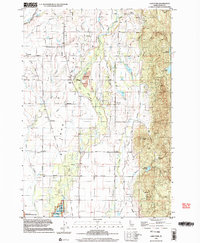
1998 Map of Lake Fork
USGS Topo · Published 2003About this map
Long Valley serves as the central geographic feature of this Idaho interior, where the settlement of Lake Fork sits at the intersection of early transportation routes. The landscape is defined by an extensive network of human-engineered water management, including the East Fork Roseberry Ditch, various canals, and a flume, all designed to support the valley's ranching and agricultural life. In the southwestern corner, the Lake Cascade Wildlife Management Area marks the transition toward the reservoir's edge.
Find a feature on this map
41 named features on this map. Tap any name to fly to it.
Don’t see what you’re looking for? This feature index may not catch every label — zoom into the map to look around manually.
Map Details
Editions of this 1998 Lake Fork Map
This is the sole edition of this map. No revisions or reprints were ever made.
Other maps of this area

1911 · Meadows
USGS Topo · 1:125,000

1954 · Gold Fork
USGS Topo · 1:62,500

1954 · Cascade
USGS Topo · 1:62,500

1955 · Baker
USGS Topo · 1:250,000

1957 · Challis
USGS Topo · 1:250,000

1959 · Baker
USGS Topo · 1:250,000

1960 · Challis
USGS Topo · 1:250,000

1963 · Challis
USGS Topo · 1:250,000
1973 · Meadows
USGS Topo · 1:24,000
1973 · No Business Mtn
USGS Topo · 1:24,000