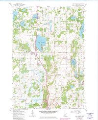
1961 Map of Lake Fremont
USGS Topo · Published 1980About this map
The Lake Fremont (Zimmerman PO) settlement serves as a focal point for this portion of Sherburne County, situated where the Great Northern railroad cuts through the glacial landscape. The terrain is defined by an intricate network of wetlands and small lakes, including West Hunter Lake, East Hunter Lake, and Rice Lake, many of which feed into the meandering course of Tibbits Brook. Local civic life and history are reflected in the presence of the Community Hall and the Livonia Cem, while the conservation of the area is highlighted by the Fremont Wildlife Management Area. This 1961 survey, updated through 1980, captures the rural character of Livonia and Baldwin townships before significant modern expansion, preserving the location of family-named landmarks like Whitney Cem and the Lookout Tower overlooking the lake country.
Find a feature on this map
36 named features on this map. Tap any name to fly to it.
Don’t see what you’re looking for? This feature index may not catch every label — zoom into the map to look around manually.
Map Details
Editions of this 1961 Lake Fremont Map
3 editions found
Other maps of this area

1916 · St. Francis
USGS Topo · 1:62,500

1919 · St. Francis
USGS Topo · 1:62,500

1953 · Stillwater
USGS Topo · 1:250,000

1955 · Stillwater
USGS Topo · 1:250,000

1958 · Stillwater
USGS Topo · 1:250,000

1961 · Big Lake
USGS Topo · 1:24,000

1961 · Orrock
USGS Topo · 1:24,000

1961 · Lake Fremont
USGS Topo · 1:24,000

1961 · Elk River
USGS Topo · 1:24,000

1961 · Wyanett
USGS Topo · 1:24,000