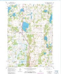
1961 Map of Lake Fremont
USGS Topo · Published 1987About this map
The settlement of Lake Fremont (Zimmerman PO) serves as the primary hub in this Sherburne County landscape, where the Great Northern railroad line cuts a definitive north-south path through the glacial lake country. The terrain is characterized by an intricate network of wetlands and named water bodies including Cantlin Lake, Sandy Lake, and the twin basins of West Hunter Lake and East Hunter Lake. This area, documented in 1961 and updated in 1980, shows a rural community defined by its water resources and conservation land, notably the Fremont Wildlife Management Area. Genealogists and local historians can find significant landmarks such as Livonia Cem and Whitney Cem, while the drainage patterns of Tibbits Brook and Spencer Brook reveal the underlying hydrology that shaped the township's development. Small-scale industrial activity is evidenced by several Gravel Pit locations near the railroad, supporting the infrastructure of growing Livonia.
Find a feature on this map
32 named features on this map. Tap any name to fly to it.
Don’t see what you’re looking for? This feature index may not catch every label — zoom into the map to look around manually.
Map Details
Editions of this 1961 Lake Fremont Map
3 editions found
Other maps of this area

1916 · St. Francis
USGS Topo · 1:62,500

1919 · St. Francis
USGS Topo · 1:62,500

1953 · Stillwater
USGS Topo · 1:250,000

1955 · Stillwater
USGS Topo · 1:250,000

1958 · Stillwater
USGS Topo · 1:250,000

1961 · Big Lake
USGS Topo · 1:24,000

1961 · Orrock
USGS Topo · 1:24,000

1961 · Lake Fremont
USGS Topo · 1:24,000

1961 · Elk River
USGS Topo · 1:24,000

1961 · Wyanett
USGS Topo · 1:24,000