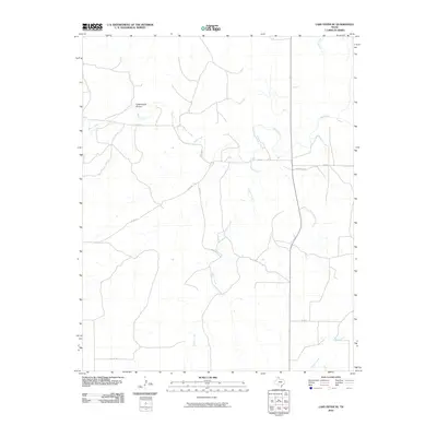
2010 Map of Lake Fryer NE
USGS Topo · Published 2010About this map
Wolf Creek meanders across this Panhandle landscape, serving as the primary drainage for the surrounding ranchlands in the northeast corner of Lipscomb County. The terrain is defined by a series of intermittent watercourses and draws, including the distinctive Cottonwood Arroyo and the southern reaches of Gilhula Creek. This 2010 survey illustrates the rural infrastructure of the era, where a network of county roads like Co RD U and Co RD 25 provides access to remote acreage. The junction of Ranch Rd 3260 and Fm 3260 indicates a shift toward more established transportation routes in the eastern portion of the quadrangle. In the south, the headwaters of Gibson Creek and Buffalo Creek begin their descent through the breaks, marking the subtle but important shifts in topography that dictate the placement of local homesteads and ranch boundaries.
Find a feature on this map
13 named features on this map. Tap any name to fly to it.
Don’t see what you’re looking for? This feature index may not catch every label — zoom into the map to look around manually.
Map Details
Editions of this 2010 Lake Fryer NE Map
This is the sole edition of this map. No revisions or reprints were ever made.
Other maps of this area

1954 · Perryton
USGS Topo · 1:250,000

1958 · Perryton
USGS Topo · 1:250,000

1972 · Barton Corners
USGS Topo · 1:24,000
1972 · Lipscomb SW
USGS Topo · 1:24,000

1972 · Twin Grove
USGS Topo · 1:24,000

1972 · Booker SE
USGS Topo · 1:24,000

1973 · Booker SW
USGS Topo · 1:24,000

1973 · Pickett Ranch Creek
USGS Topo · 1:24,000

1973 · Lake Fryer
USGS Topo · 1:24,000
1973 · Barton Creek
USGS Topo · 1:24,000