
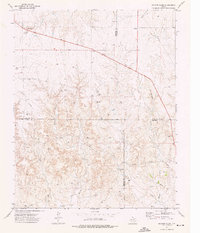
1973 Map of Pickett Ranch Creek
USGS Topo · Published 1975About this map
The Ochiltree Co and Roberts Co boundary line bisects this 1970s landscape, revealing an industrial geography defined by a sprawling Oil And Gas Field. Numerous sites for Oil Wells, Gas Wells, and general Wells are scattered across the terrain, linked by an extensive network of Pipelines. This energy infrastructure follows the contours of the land, cutting across a system of drainages led by Pickett Ranch Creek and its Northwest Fork.
Find a feature on this map
15 named features on this map. Tap any name to fly to it.
Don’t see what you’re looking for? This feature index may not catch every label — zoom into the map to look around manually.
Map Details
Editions of this 1973 Pickett Ranch Creek Map
This is the sole edition of this map. No revisions or reprints were ever made.
Other maps of this area

1954 · Perryton
USGS Topo · 1:250,000

1954 · Amarillo
USGS Topo · 1:250,000

1958 · Perryton
USGS Topo · 1:250,000

1958 · Amarillo
USGS Topo · 1:250,000

1971 · Dry Creek NE
USGS Topo · 1:24,000

1972 · Horse Creek North
USGS Topo · 1:24,000

1972 · East Dry Creek
USGS Topo · 1:24,000

1973 · Sourdough Creek NE
USGS Topo · 1:24,000

1973 · Lake Fryer
USGS Topo · 1:24,000
1973 · Barton Creek
USGS Topo · 1:24,000