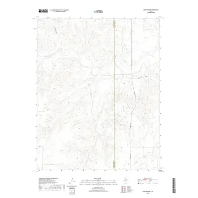
2019 Map of Lake Fryer NE
USGS Topo · Published 2019About this map
Ochiltree and Lipscomb Counties meet along a sharp North-South divide in this High Plains region, where the terrain is deeply dissected by drainage systems feeding into the Wolf Cr basin. The landscape is defined by its watercourses, including the notable Cottonwood Arroyo and Gibson Cr, which have carved intricate contour patterns into the panhandle soil. A sparse network of local thoroughfares, such as Co RD U and Co RD 29, provides the primary access to the large agricultural tracts and ranchlands that characterize this border region. The 2019 survey highlights the intersection of modern infrastructure and natural hydrology, with Ranch Rd 1265 running north through the eastern half of the map, crossing Wolf Cr as it traverses the expansive, open range typical of the Texas Panhandle.
Find a feature on this map
16 named features on this map. Tap any name to fly to it.
Don’t see what you’re looking for? This feature index may not catch every label — zoom into the map to look around manually.
Map Details
Editions of this 2019 Lake Fryer NE Map
This is the sole edition of this map. No revisions or reprints were ever made.
Other maps of this area

1954 · Perryton
USGS Topo · 1:250,000

1958 · Perryton
USGS Topo · 1:250,000

1972 · Barton Corners
USGS Topo · 1:24,000
1972 · Lipscomb SW
USGS Topo · 1:24,000

1972 · Twin Grove
USGS Topo · 1:24,000

1972 · Booker SE
USGS Topo · 1:24,000

1973 · Booker SW
USGS Topo · 1:24,000

1973 · Pickett Ranch Creek
USGS Topo · 1:24,000

1973 · Lake Fryer
USGS Topo · 1:24,000
1973 · Barton Creek
USGS Topo · 1:24,000