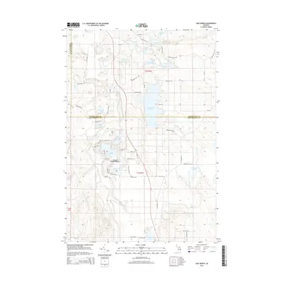
2014 Map of Lake Geneva
USGS Topo · Published 2014About this map
Canada Creek Ranch occupies a central role in this northern Michigan landscape, characterized by an intricate network of waterways and glacial lakes. Located at the intersection of Presque Isle and Montmorency counties, the area is defined by the winding course of Tomahawk Cr and the expansive Tomahawk Cr Flooding. The settlement's layout is reflected in a dense web of named trails and roads such as W Bergon Dr, Conifer Trl, and Wintergreen Trl, suggesting a community deeply integrated with its natural surroundings.
Find a feature on this map
58 named features on this map. Tap any name to fly to it.
Don’t see what you’re looking for? This feature index may not catch every label — zoom into the map to look around manually.
Map Details
Editions of this 2014 Lake Geneva Map
This is the sole edition of this map. No revisions or reprints were ever made.
Other maps of this area

1954 · Hetherton
USGS Topo · 1:62,500

1955 · Atlanta
USGS Topo · 1:62,500

1955 · Cheboygan
USGS Topo · 1:250,000

1957 · Tower
USGS Topo · 1:62,500

1957 · Onaway
USGS Topo · 1:62,500

1958 · Cheboygan
USGS Topo · 1:250,000

1982 · Petoskey
USGS Topo · 1:100,000
1986 · Onaway
USGS Topo · 1:24,000

1986 · Silver Lake
USGS Topo · 1:24,000
1986 · Atlanta SE
USGS Topo · 1:24,000
Featured Places
- Canada Creek Ranch, MI
- Montmorency Township, MI
- Allis Township, MI
- Forest Township, MI
- Cheboygan County, MI