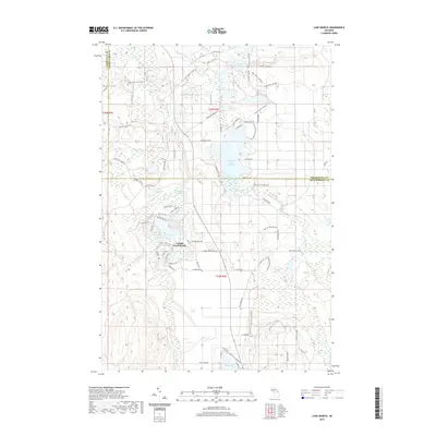
2019 Map of Lake Geneva
USGS Topo · Published 2019About this map
Canada Creek Ranch serves as a primary point of interest in this northern Michigan landscape, situated at the border of Presque Isle and Montmorency counties. The geography is defined by an intricate network of glacial lakes and managed waterways, most notably Lake Geneva, Virginia Lake, and the expansive Tomahawk Creek Flooding. This area, heavily influenced by its proximity to state forest lands, features a dense system of recreational trails and forest roads. The High Country Pathway winds through the eastern half of the map, while specialized routes like the Clear Lake-Jackson Lake Pathway and various ATV Trails provide access to the interior. The drainage patterns of Tomahawk Creek and Canada Creek reveal the hydrological complexity of the region, where numerous named lakes like Shoepac Lake and Little Tomahawk Lake are scattered across the timbered terrain.
Find a feature on this map
71 named features on this map. Tap any name to fly to it.
Don’t see what you’re looking for? This feature index may not catch every label — zoom into the map to look around manually.
Map Details
Editions of this 2019 Lake Geneva Map
This is the sole edition of this map. No revisions or reprints were ever made.
Other maps of this area

1954 · Hetherton
USGS Topo · 1:62,500

1955 · Atlanta
USGS Topo · 1:62,500

1955 · Cheboygan
USGS Topo · 1:250,000

1957 · Tower
USGS Topo · 1:62,500

1957 · Onaway
USGS Topo · 1:62,500

1958 · Cheboygan
USGS Topo · 1:250,000

1982 · Petoskey
USGS Topo · 1:100,000
1986 · Onaway
USGS Topo · 1:24,000

1986 · Silver Lake
USGS Topo · 1:24,000
1986 · Atlanta SE
USGS Topo · 1:24,000
Featured Places
- Canada Creek Ranch, MI
- Montmorency Township, MI
- Allis Township, MI
- Forest Township, MI
- Cheboygan County, MI