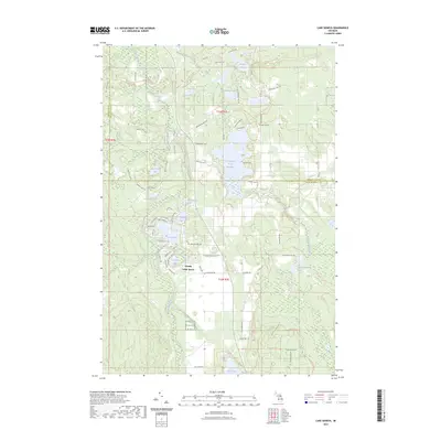
2023 Map of Lake Geneva
USGS Topo · Published 2023About this map
Canada Creek Ranch serves as a central point of interest in this northern Michigan landscape, where the borders of Cheboygan, Presque Isle, and Montmorency Counties converge. The terrain is defined by an intricate network of glacial lakes and wetlands, most notably the Tomahawk Creek Flooding and Lake Geneva. Extensive trail systems, including the High Country Pathway Trl and the Sinkhole Pathway Trl, weave through the timbered sections, reflecting the region's focus on conservation and outdoor recreation. A significant portion of the southern area is dedicated to the Kirtlands Warbler W M A, a specialized wildlife management area highlighting the unique ecological niche of this territory. From the secluded Twin Tomahawk Lakes to the shores of Clear Lake, the map provides a precise record of water bodies and backcountry routes that have shaped local geography for decades.
Find a feature on this map
77 named features on this map. Tap any name to fly to it.
Don’t see what you’re looking for? This feature index may not catch every label — zoom into the map to look around manually.
Map Details
Editions of this 2023 Lake Geneva Map
This is the sole edition of this map. No revisions or reprints were ever made.
Other maps of this area

1954 · Hetherton
USGS Topo · 1:62,500

1955 · Atlanta
USGS Topo · 1:62,500

1955 · Cheboygan
USGS Topo · 1:250,000

1957 · Tower
USGS Topo · 1:62,500

1957 · Onaway
USGS Topo · 1:62,500

1958 · Cheboygan
USGS Topo · 1:250,000

1982 · Petoskey
USGS Topo · 1:100,000
1986 · Onaway
USGS Topo · 1:24,000

1986 · Silver Lake
USGS Topo · 1:24,000
1986 · Atlanta SE
USGS Topo · 1:24,000
Featured Places
- Canada Creek Ranch, MI
- Allis Township, MI
- Montmorency Township, MI
- Forest Township, MI
- Cheboygan County, MI