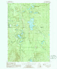
1986 Map of Lake Geneva
USGS Topo · Published 1986About this map
Canada Creek Ranch serves as a primary point of human settlement in this mid-1980s landscape, which is heavily defined by the extensive water systems of the Mackinaw State Forest. The map documents a dense network of glacial lakes and wetlands, including the central Tomahawk Lake and the Mackinaw Flooding, where Tomahawk Creek is widened and shaped by northern hydrology. To the south, Clear Lake State Park provides a recreational anchor near Clear Lake. This provisional survey illustrates the land's transition between the borders of Cheboygan, Presque Isle, and Montmorency counties. The topography is marked by numerous small, isolated basins like Shoepac Lake and Bear Den Lake, connected by minor waterways such as Canada Creek and Montague Creek, reflecting a region largely preserved for forest management and conservation.
Find a feature on this map
24 named features on this map. Tap any name to fly to it.
Don’t see what you’re looking for? This feature index may not catch every label — zoom into the map to look around manually.
Map Details
Editions of this 1986 Lake Geneva Map
This is the sole edition of this map. No revisions or reprints were ever made.
Other maps of this area

1954 · Hetherton
USGS Topo · 1:62,500

1955 · Atlanta
USGS Topo · 1:62,500

1955 · Cheboygan
USGS Topo · 1:250,000

1957 · Tower
USGS Topo · 1:62,500

1957 · Onaway
USGS Topo · 1:62,500

1958 · Cheboygan
USGS Topo · 1:250,000

1982 · Petoskey
USGS Topo · 1:100,000
1986 · Onaway
USGS Topo · 1:24,000

1986 · Silver Lake
USGS Topo · 1:24,000
1986 · Atlanta SE
USGS Topo · 1:24,000
Featured Places
- Canada Creek Ranch, MI
- Forest Township, MI
- Allis Township, MI
- Montmorency Township, MI
- Cheboygan County, MI