1960 Map of Lake Geneva
USGS Topo · Published 1963About this map
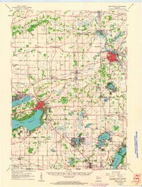
Geneva Lake and the Fox River anchor this 1960s landscape, illustrating a region defined by its glacial hydrology and established summer colonies. The map details the urban cores of Lake Geneva and Burlington, where the density of landmark buildings and the convergence of the Chicago Milwaukee St Paul and Pacific and Chicago and North Western railroads reflect the area's mid-century role as a major regional hub.
Find a feature on this map
94 named features on this map. Tap any name to fly to it.
Don’t see what you’re looking for? This feature index may not catch every label — zoom into the map to look around manually.
Map Details
Editions of this 1960 Lake Geneva Map
This is the sole edition of this map. No revisions or reprints were ever made.
Other maps of this area

1891 · Muskego
USGS Topo · 1:62,500

1892 · Whitewater
USGS Topo · 1:62,500

1892 · Eagle
USGS Topo · 1:62,500

1893 · Delavan
USGS Topo · 1:62,500

1893 · Whitewater
USGS Topo · 1:62,500

1893 · Silver Lake
USGS Topo · 1:62,500

1893 · Geneva
USGS Topo · 1:62,500

1894 · Eagle
USGS Topo · 1:62,500

1897 · Eagle
USGS Topo · 1:62,500

1901 · Muskego
USGS Topo · 1:62,500