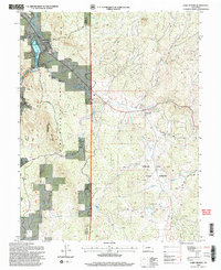
1994 Map of Lake George
USGS Topo · Published 1998About this map
The South Platte River and its accompanying Lake George reservoir anchor the western edge of this Colorado landscape, where the high country transitions into the preserved geological wonders of the Florissant Fossil Beds National Monument. This area, split by the Park Co Teller Co boundary, shows a distinct pattern of settlement and recreation, from the concentrated townsite of Lake George to the Camp Alexander scout camp.
Find a feature on this map
25 named features on this map. Tap any name to fly to it.
Don’t see what you’re looking for? This feature index may not catch every label — zoom into the map to look around manually.
Map Details
Editions of this 1994 Lake George Map
2 editions found
Other maps of this area

1893 · Platte Canyon
USGS Topo · 1:125,000

1894 · Pikes Peak
USGS Topo · 1:125,000

1901 · Pikes Peak
USGS Topo · 1:125,000

1901 · Pikes Peak
USGS Topo · 1:62,500

1951 · Cripple Creek North
USGS Topo · 1:24,000

1953 · Denver
USGS Topo · 1:250,000

1954 · Signal Butte
USGS Topo · 1:24,000

1954 · Divide
USGS Topo · 1:24,000

1954 · Pueblo
USGS Topo · 1:250,000

1956 · Tarryall
USGS Topo · 1:24,000