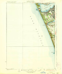
1936 Map of Lake Harbor
USGS Topo · Published 1936About this map
Muskegon Lake serves as the focal point of this coastal survey, where the industrial and residential development of the early 1930s is visible along the eastern shores of Lake Michigan. The map illustrates the expansion of Muskegon and Muskegon Heights, showing the dense grid of streets and the P M Ry and G T Ry rail lines that fueled the region's growth. To the south, the landscape transitions from the urban center toward Lake Harbor and the shores of Mona Lake, where smaller settlements like Indian Village appear. Along the immediate coastline, recreational and navigational landmarks such as Pere Marquette Park, Port Sherman, and the prominent Pigeon Hill highlight the intersection of the city’s maritime utility and its emerging lakefront identity. The presence of rural schoolhouses like Maple Grove Sch and Green Creek Sch No 20 provides a window into the organized townships of Norton and Laketon during this era.
Find a feature on this map
29 named features on this map. Tap any name to fly to it.
Don’t see what you’re looking for? This feature index may not catch every label — zoom into the map to look around manually.
Map Details
Editions of this 1936 Lake Harbor Map
3 editions found
Other maps of this area

1929 · Montague
USGS Topo · 1:48,000

1929 · Holland
USGS Topo · 1:62,500

1930 · Lake Harbor
USGS Topo · 1:48,000

1930 · Muskegon
USGS Topo · 1:62,500

1932 · Holland
USGS Topo · 1:62,500

1936 · Muskegon
USGS Topo · 1:62,500

1936 · Lake Harbor
USGS Topo · 1:62,500

1954 · Milwaukee
USGS Topo · 1:250,000

1958 · Milwaukee
USGS Topo · 1:250,000

1958 · Twin Lake
USGS Topo · 1:62,500