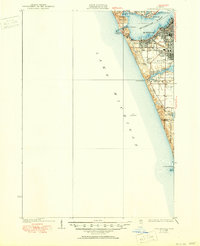
1936 Map of Lake Harbor
USGS Topo · Published 1950About this map
Muskegon Lake and the eastern shore of Lake Michigan define this 1930s coastal landscape, where the industrial growth of Muskegon and Muskegon Heights meets the recreational character of the shoreline. The map captures a transition as the area developed around the natural harbors of Mona Lake and Little Black Lake, with the P M Ry and G T Ry providing essential rail connections to the lakeside industries. Beyond the urban centers, smaller settlements like Port Sherman and Indian Village appear alongside early civic landmarks such as Maple Grove Sch and Bronson Park. The terrain is marked by significant dunes and landmarks like Pigeon Hill, emphasizing the geographic barriers that shaped early road planning, including the winding Scenic Drive that follows the lakefront.
Find a feature on this map
31 named features on this map. Tap any name to fly to it.
Don’t see what you’re looking for? This feature index may not catch every label — zoom into the map to look around manually.
Map Details
Editions of this 1936 Lake Harbor Map
3 editions found
Other maps of this area

1929 · Montague
USGS Topo · 1:48,000

1929 · Holland
USGS Topo · 1:62,500

1930 · Lake Harbor
USGS Topo · 1:48,000

1930 · Muskegon
USGS Topo · 1:62,500

1932 · Holland
USGS Topo · 1:62,500

1936 · Muskegon
USGS Topo · 1:62,500

1936 · Lake Harbor
USGS Topo · 1:62,500

1954 · Milwaukee
USGS Topo · 1:250,000

1958 · Milwaukee
USGS Topo · 1:250,000

1958 · Twin Lake
USGS Topo · 1:62,500