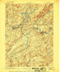
1905 Map of Lake Hopatcong
USGS Topo · Published 1921About this map
Lake Hopatcong serves as the centerpiece of this northern New Jersey survey, surrounded by islands like Halsey Island and early lakeside settlements including Hopatcong and Landing. The landscape is defined by its industrial and transportation complexity at the start of the 20th century. A dense network of rail lines, such as the Delaware Lackawanna and Western Railroad and the High Bridge Branch, connects iron-rich hills and depots.
Find a feature on this map
109 named features on this map. Tap any name to fly to it.
Don’t see what you’re looking for? This feature index may not catch every label — zoom into the map to look around manually.
Map Details
Editions of this 1905 Lake Hopatcong Map
3 editions found
Other maps of this area

1888 · Franklin
USGS Topo · 1:62,500

1888 · Plainfield
USGS Topo · 1:62,500

1888 · Morristown
USGS Topo · 1:62,500

1888 · Hackettstown
USGS Topo · 1:62,500

1888 · Lake Hopatcong
USGS Topo · 1:62,500

1890 · High Bridge
USGS Topo · 1:62,500

1891 · Somerville
USGS Topo · 1:62,500

1891 · Greenwood Lake
USGS Topo · 1:62,500

1891 · Wallpack
USGS Topo · 1:62,500

1893 · Plainfield
USGS Topo · 1:62,500
Featured Places
- Parsippany-Troy Hills, NJ
- Mount Olive, NJ
- Rockaway Township, NJ
- Roxbury Township, NJ
- Sparta Township, NJ