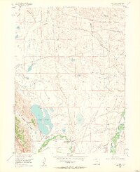
1955 Map of Lake John
USGS Topo · Published 1963About this map
Lake John and its surrounding high-plains ranching operations dominate this 1955 survey of the Jackson County landscape. The mapping reveals an intricate network of irrigation systems essential to high-altitude agriculture, including the Bighorn Cattle Company Ditch and the Legal Tender Ditch. Local cattle ranching history is anchored by the presence of Brands Ranch and Wattenberg Ranch, while the namesake lake and nearby Alkali Lake represent the primary water resources of the basin. The eastern slopes of Sheep Mountain descend into the valley of the North Fork North Platte River, where the river winds through meadows crisscrossed by various family-named water projects like the Reithmeyer and Wattenberg Ditch. This era of the mid-twentieth century shows the high country before modern expansion, when water rights and seasonal grazing defined the North Park region's character.
Find a feature on this map
27 named features on this map. Tap any name to fly to it.
Don’t see what you’re looking for? This feature index may not catch every label — zoom into the map to look around manually.
Map Details
Editions of this 1955 Lake John Map
4 editions found
Other maps of this area

1911 · Hahns Peak
USGS Topo · 1:125,000

1913 · Hahns Peak
USGS Topo · 1:125,000

1950 · Northgate
USGS Topo · 1:24,000

1952 · Northgate
USGS Topo · 1:24,000

1954 · Craig
USGS Topo · 1:250,000

1955 · Independence Mountain
USGS Topo · 1:24,000

1955 · Lake John
USGS Topo · 1:24,000

1955 · Pitchpine Mountain
USGS Topo · 1:24,000

1955 · Delaney Butte
USGS Topo · 1:24,000

1955 · Pearl
USGS Topo · 1:24,000