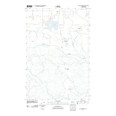
2011 Map of Lake Lawrence
USGS Topo · Published 2011About this map
Lake Lawrence and its surrounding water systems define this portion of the Puget Sound lowlands as it appeared in the early 21st century. The landscape transition is evident where the residential grid of Smith Prairie meets the winding Deschutes River, which flows past landmarks like the Prince Dam and Reichel Ranch. Further south, the terrain rises into more industrial and wooded upland areas, marked by Shell Rock Ridge and Porcupine Ridge, which culminates at the Porcupine Lookout. The southern reaches of the map show the headwaters of the Skookumchuck River and its various tributaries, including Hospital Creek and Fall Creek, as they carve through the timbered slopes around Clam Mountain. This geography reveals a clear distinction between the developed lakefront communities and the managed forest lands to the south.
Find a feature on this map
58 named features on this map. Tap any name to fly to it.
Don’t see what you’re looking for? This feature index may not catch every label — zoom into the map to look around manually.
Map Details
Editions of this 2011 Lake Lawrence Map
This is the sole edition of this map. No revisions or reprints were ever made.
Other maps of this area

1916 · Chehalis
USGS Topo · 1:125,000

1937 · Eatonville
USGS Topo · 1:125,000

1941 · Tanwax Lake
USGS Topo · 1:62,500

1943 · Willapa
USGS Topo · 1:62,500

1944 · Yelm
USGS Topo · 1:62,500

1944 · Ohop Valley
USGS Topo · 1:62,500

1949 · Ohop Valley
USGS Topo · 1:62,500

1949 · Yelm
USGS Topo · 1:62,500

1953 · Hoquiam
USGS Topo · 1:250,000

1954 · Onalaska
USGS Topo · 1:62,500