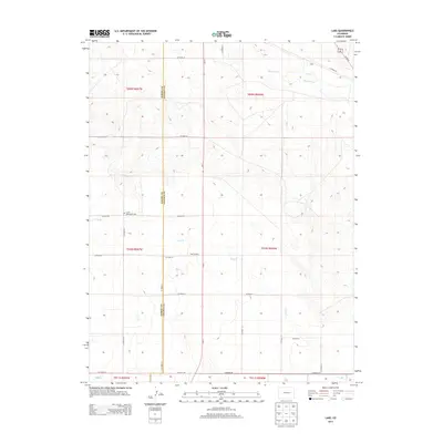
2013 Map of Lake
USGS Topo · Published 2013About this map
Elbert Co Lincoln Co divides this High Plains landscape, where the agricultural grid meets the natural drainage of the Big Sandy Cr watershed. The survey reflects a sparsely populated ranching and farming region defined by a precise network of section roads, such as CO Road 19 and CO Road 90, which connect isolated homesteads and local landmarks. Notable community features include the Limon Mennonite Cem and the junction at Four Corners, providing specific points of interest for genealogists tracing family ties to this borderland. Intermittent watercourses like Lake Cr, Long Br, and Long Cr carve subtle variations into the terrain, indicating the critical role of water management in this arid part of Eastern Colorado during the early 21st century.
Find a feature on this map
31 named features on this map. Tap any name to fly to it.
Don’t see what you’re looking for? This feature index may not catch every label — zoom into the map to look around manually.
Map Details
Editions of this 2013 Lake Map
This is the sole edition of this map. No revisions or reprints were ever made.
Other maps of this area

1891 · Limon
USGS Topo · 1:125,000

1892 · Limon
USGS Topo · 1:125,000

1954 · Limon
USGS Topo · 1:250,000

1957 · Limon
USGS Topo · 1:250,000

1958 · Limon
USGS Topo · 1:250,000
1970 · Matheson SE
USGS Topo · 1:24,000

1970 · Limon
USGS Topo · 1:24,000

1970 · Four Corners
USGS Topo · 1:24,000
1970 · Long Creek
USGS Topo · 1:24,000
1970 · Matheson NE
USGS Topo · 1:24,000