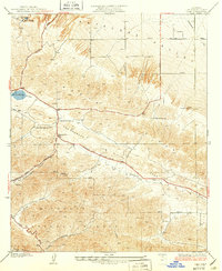
1937 Map of Lake
USGS Topo · Published 1937About this map
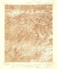
The San Andreas Rift Zone bisects this landscape, creating a distinct geological trough where the Elizabeth Lake Road and Pine Canyon Road now run. At the heart of this corridor lies Elizabeth Lake, a significant natural catchment along the fault line. During the 1930s, this area served as a transition between the high desert of the Antelope Valley and the steep terrain of the Angeles National Forest. Small-scale ranching and early mountain settlements are visible through markers like the Elizabeth Lake Ranch and the Elizabeth Lake Sch, while family-named sites such as Talamantes and Hitchbrook Ranch dot the valley floor. High-tension Transmission Line corridors and the grid of the Antelope Valley, including Avenue J and Avenue K, illustrate the encroachment of infrastructure into this geologically active corner of Los Angeles County.
Find a feature on this map
32 named features on this map. Tap any name to fly to it.
Don’t see what you’re looking for? This feature index may not catch every label — zoom into the map to look around manually.
Map Details
Editions of this 1937 Lake Map
3 editions found
Other maps of this area

1915 · Elizabeth Lake
USGS Topo · 1:125,000

1917 · Elizabeth Lake
USGS Topo · 1:125,000

1931 · Little Buttes
USGS Topo · 1:24,000

1931 · Del Sur
USGS Topo · 1:24,000

1931 · Esperanza School
USGS Topo · 1:24,000
1932 · La Brun
USGS Topo · 1:24,000

1932 · Red Rover
USGS Topo · 1:24,000

1932 · Lake
USGS Topo · 1:24,000
1932 · Mint Canyon
USGS Topo · 1:24,000

1932 · Hughes Lake
USGS Topo · 1:24,000