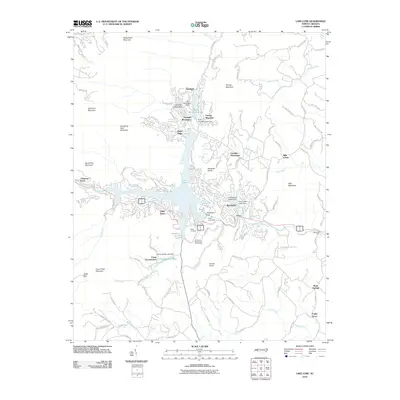
2010 Map of Lake Lure
USGS Topo · Published 2010About this map
Lake Lure serves as the central focal point for this mountain landscape, which by 2010 was characterized by established lakeside communities and recreation camps. The Broad River flows through the valley, regulated by a series of hydroelectric structures including the Lake Lure Dam, while smaller reservoirs like Bald Mountain Lake and Occoneechee Lake dot the surrounding ridges. Residential developments such as Fairfield Mountains, Deerfield, and Carolina Mountains demonstrate the area's growth as a mountain retreat. High-elevation landmarks like Rumbling Bald Mountain and Chimney Rock overlook the waters, where recreational sites such as Camp Lurecrest, Camp Occoneechee, and the Lake Lure Municipal Golf Course are nestled along the shorelines. Smaller settlements like Uree and Poplar Grove occupy the eastern valleys, connected by a network of winding roads like Chimney Rock Scenic Rd and Grassy Knob Rd that navigate the varied terrain.
Find a feature on this map
111 named features on this map. Tap any name to fly to it.
Don’t see what you’re looking for? This feature index may not catch every label — zoom into the map to look around manually.
Map Details
Editions of this 2010 Lake Lure Map
This is the sole edition of this map. No revisions or reprints were ever made.
Other maps of this area

1900 · Mount Mitchell
USGS Topo · 1:125,000

1902 · Mount Mitchell
USGS Topo · 1:125,000

1907 · Saluda
USGS Topo · 1:125,000

1935 · Batcave
USGS Topo · 1:24,000

1935 · Black Mountain
USGS Topo · 1:24,000

1935 · Fishtop
USGS Topo · 1:24,000

1941 · Black Mountain
USGS Topo · 1:24,000
1943 · Black Mountain
USGS Topo · 1:24,000

1946 · Bat Cave
USGS Topo · 1:24,000

1946 · Cliffield Mtn
USGS Topo · 1:24,000