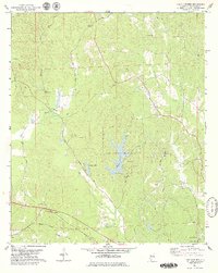
1978 Map of Lake Lurleen
USGS Topo · Published 1979About this map
Lake Lurleen State Park and the waters of Lake Lurleen anchor this 1970s landscape northwest of Tuscaloosa. The terrain is defined by a dense network of local watercourses including Wards Mill Creek, Big Creek, and Carroll Creek, which flow through heavily wooded areas marked by numerous rural congregations and family burial grounds. The historical transit of the region is evident in the Jackson Trace roadway and the presence of the Mobile and Gulf RR and Illinois Central Gulf rail lines passing through the settlement at Buhl.
Find a feature on this map
31 named features on this map. Tap any name to fly to it.
Don’t see what you’re looking for? This feature index may not catch every label — zoom into the map to look around manually.
Map Details
Editions of this 1978 Lake Lurleen Map
3 editions found
Other maps of this area

1924 · Tuscaloosa
USGS Topo · 1:62,500

1926 · Samantha
USGS Topo · 1:48,000

1926 · Tuscaloosa
USGS Topo · 1:62,500

1928 · Samantha
USGS Topo · 1:62,500

1953 · Birmingham
USGS Topo · 1:250,000

1956 · Birmingham
USGS Topo · 1:250,000

1957 · Birmingham
USGS Topo · 1:250,000

1967 · Brownville
USGS Topo · 1:24,000

1967 · Elrod
USGS Topo · 1:24,000
1969 · Coker
USGS Topo · 1:24,000