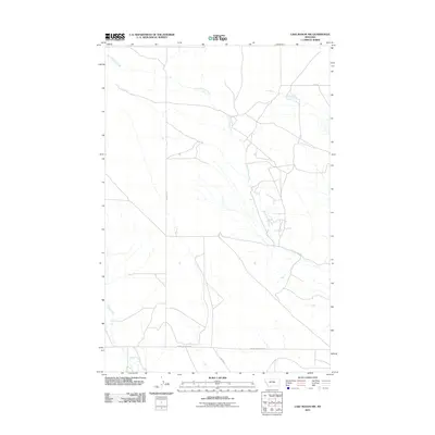
2011 Map of Lake Mason NW
USGS Topo · Published 2011About this map
North Willow Creek meanders through this portion of Fergus County, defining a drainage pattern that dictates the local road network. The landscape is characterized by a high-plains geography where water sources are the primary landmarks. Routes like Snowy Mountain Rd and Harris Rd segment the terrain into large agricultural or grazing blocks typical of central Montana. In the southwest, the headwaters of Jones Creek and Willow Creek suggest a subtly shifting topography as the land moves away from the more prominent northern creek system. This 2011 survey provides a clear view of the modern rural infrastructure, where long-established dirt and gravel roads follow section lines to connect isolated ranching properties.
Find a feature on this map
7 named features on this map. Tap any name to fly to it.
Don’t see what you’re looking for? This feature index may not catch every label — zoom into the map to look around manually.
Map Details
Editions of this 2011 Lake Mason NW Map
This is the sole edition of this map. No revisions or reprints were ever made.
Other maps of this area

1954 · Roundup
USGS Topo · 1:250,000

1958 · Roundup
USGS Topo · 1:250,000

1986 · Tyler
USGS Topo · 1:24,000

1986 · Lake Mason SE
USGS Topo · 1:24,000

1986 · Pender Coulee
USGS Topo · 1:24,000

1986 · Pike Creek Hills West
USGS Topo · 1:24,000

1986 · Lake Mason NE
USGS Topo · 1:24,000

1986 · Lake Mason NW
USGS Topo · 1:24,000

1986 · Pike Creek Hills East
USGS Topo · 1:24,000
1986 · Timber Buttes North
USGS Topo · 1:24,000