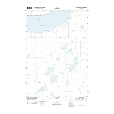
2010 Map of Lake Minnewaska
USGS Topo · Published 2010About this map
Lake Minnewaska dominates the northern landscape of this Pope County region, characterized by its irregular shoreline and prominent features like Lawrence Point and Swenson Point. The surrounding terrain is a complex glacial landscape dotted with numerous smaller basins, including Steenerson Lake, Lake Jennum, and the elongated Lake Ben. This 2010 survey reflects a rural environment where land use is defined by a grid of county and township roads, such as County Hwy-13 and County Hwy-16.
Find a feature on this map
47 named features on this map. Tap any name to fly to it.
Don’t see what you’re looking for? This feature index may not catch every label — zoom into the map to look around manually.
Map Details
Editions of this 2010 Lake Minnewaska Map
This is the sole edition of this map. No revisions or reprints were ever made.
Other maps of this area

1953 · Saint Cloud
USGS Topo · 1:250,000

1957 · Saint Cloud
USGS Topo · 1:250,000

1958 · Saint Cloud
USGS Topo · 1:250,000

1968 · Starbuck
USGS Topo · 1:24,000

1968 · Lowry
USGS Topo · 1:24,000

1968 · Glenwood
USGS Topo · 1:24,000

1968 · Terrace
USGS Topo · 1:24,000
1968 · Villard
USGS Topo · 1:24,000

1968 · Lake Hassel
USGS Topo · 1:24,000

1968 · Lake Simon
USGS Topo · 1:24,000