
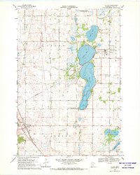
1968 Map of Glenwood
USGS Topo · Published 1970About this map
Lake Minnewaska and Lake Reno anchor this landscape of central Minnesota glacial lakes during the late 1960s. The city of Glenwood serves as the regional hub, situated at the northeast corner of the water, where the Pacific and Soo Line railroads converge. This era shows a community deeply tied to its geography, with extensive conservation efforts visible in the Reno State Wildlife Management Areas and the Star Lake State Wildlife Management Area. Local history is preserved in the numerous country institutions dotting the township lines, including the Lake Reno Sch, Lake Reno Ch, and the Swedish Mission Cem. Along the shoreline of the larger lakes, developments like Long Beach and several named points such as Woodland Point and Eagles Point illustrate the area's transition into a recreational and residential destination.
Find a feature on this map
44 named features on this map. Tap any name to fly to it.
Don’t see what you’re looking for? This feature index may not catch every label — zoom into the map to look around manually.
Map Details
Editions of this 1968 Glenwood Map
This is the sole edition of this map. No revisions or reprints were ever made.
Other maps of this area

1953 · Saint Cloud
USGS Topo · 1:250,000

1957 · Saint Cloud
USGS Topo · 1:250,000

1958 · Saint Cloud
USGS Topo · 1:250,000

1966 · Farwell
USGS Topo · 1:24,000

1966 · Lake Mary
USGS Topo · 1:24,000

1966 · Forada
USGS Topo · 1:24,000

1968 · Starbuck
USGS Topo · 1:24,000

1968 · Lowry
USGS Topo · 1:24,000

1968 · Terrace
USGS Topo · 1:24,000
1968 · Villard
USGS Topo · 1:24,000