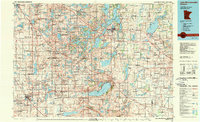
1986 Map of Lake Minnewaska
USGS Topo · Published 1990About this map
The glacial lakes region of West Central Minnesota is prominently displayed in this 1980s landscape, centered on the expansive waters of Lake Minnewaska. The city of Glenwood serves as a primary hub on the eastern shore, while the Soo Line and Burlington Northern railroads trace the movement of grain and goods across the prairie. The map details a transition from the dense cluster of lakes near Alexandria, such as Lake Carlos and Lake Ida, to the river-fed plains of Morris in the southwest. A significant portion of the land is dedicated to conservation, shown by the numerous State Wildlife Management Areas like White Bear State Wildlife Management Area and Garfield State Wildlife Management Area. These areas, combined with named landmarks like Stony Point and Lawrence Point, reveal a region where the natural hydrology of the Pomme de Terre River heavily influences settlement patterns.
Find a feature on this map
104 named features on this map. Tap any name to fly to it.
Don’t see what you’re looking for? This feature index may not catch every label — zoom into the map to look around manually.
Map Details
Editions of this 1986 Lake Minnewaska Map
2 editions found
Other maps of this area

1910 · Wendell
USGS Topo · 1:62,500

1910 · Chokio
USGS Topo · 1:62,500

1911 · Barrett
USGS Topo · 1:62,500

1911 · Herman
USGS Topo · 1:62,500

1912 · Chokio
USGS Topo · 1:62,500

1912 · Morris
USGS Topo · 1:62,500

1913 · Ashby
USGS Topo · 1:62,500

1913 · Wendell
USGS Topo · 1:62,500

1953 · Milbank
USGS Topo · 1:250,000

1953 · Fargo
USGS Topo · 1:250,000