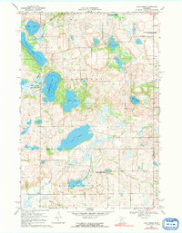
1968 Map of Lake Simon
USGS Topo · Published 1991About this map
Glacial lakes and meandering watercourses define this rural landscape on the border of Pope and Swift counties during the late 1960s. The hydrography is dominated by the sprawling Lake Simon and the distinctive Scandinavian Lake, while the Chippewa River and its East Branch provide the primary drainage. The settlement pattern is sparse, characterized by individual farmsteads and small social centers such as the Lake Johanna Ch and its adjacent Cem, along with a local Townhall further south in Kerkhoven township.
Find a feature on this map
26 named features on this map. Tap any name to fly to it.
Don’t see what you’re looking for? This feature index may not catch every label — zoom into the map to look around manually.
Map Details
Editions of this 1968 Lake Simon Map
2 editions found
Other maps of this area

1953 · Saint Cloud
USGS Topo · 1:250,000

1957 · Saint Cloud
USGS Topo · 1:250,000

1958 · Saint Cloud
USGS Topo · 1:250,000

1965 · Sedan
USGS Topo · 1:24,000

1967 · Sunburg
USGS Topo · 1:24,000

1967 · Lake Johanna
USGS Topo · 1:24,000

1968 · De Graff
USGS Topo · 1:24,000

1968 · Terrace
USGS Topo · 1:24,000

1968 · Lake Simon
USGS Topo · 1:24,000
1968 · Lake Minnewaska
USGS Topo · 1:24,000