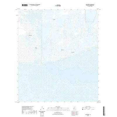
2020 Map of Lake Misere
USGS Topo · Published 2020About this map
Lake Misere and its surrounding wetlands define this coastal landscape in Cameron Parish, where land and water are inextricably linked. The southern half of the sheet is dominated by the expansive open waters of the lake, connected to Little Lake Misere by a passage known as The Narrows. This aqueous environment is bisected by the Intracoastal Waterway, a critical navigation artery that cuts through the marsh. North of the waterway, the terrain is a complex mosaic of wetlands interspersed with slightly elevated features such as Jims Ridge and Mango Ridge, which likely represent subtle cheniers or natural rises in the deltaic plain. Further east, isolated stands of timber or high ground are identified as Blue Grove and Black Grove. Engineering efforts to manage the water levels are evident in the Bell City Drainage Canal, which runs vertically across the northern reaches of the quadrangle.
Find a feature on this map
10 named features on this map. Tap any name to fly to it.
Don’t see what you’re looking for? This feature index may not catch every label — zoom into the map to look around manually.
Map Details
Editions of this 2020 Lake Misere Map
This is the sole edition of this map. No revisions or reprints were ever made.
Other maps of this area

1932 · Lake Charles SE
USGS Topo · 1:31,680

1934 · Catfish Lake
USGS Topo · 1:24,000

1934 · Lake Misere
USGS Topo · 1:24,000

1934 · Boudreaux Lake
USGS Topo · 1:24,000

1934 · Latania Lake
USGS Topo · 1:24,000

1935 · Lake Misere
USGS Topo · 1:31,680

1935 · Catfish Lake
USGS Topo · 1:31,680

1935 · Latania Lake
USGS Topo · 1:31,680

1935 · Boudreaux Lake
USGS Topo · 1:31,680

1935 · Bay Labauve
USGS Topo · 1:31,680