
1934 Map of Lake Misere
USGS Topo · Published 1955About this map
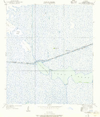
Lake Misere and the surrounding marshlands of Cameron Parish define this landscape as it was surveyed in the early 1930s. The small settlement of Misere sits along the southern shore, while the Intracoastal Waterway cuts a straight path through the wetlands to the north. This survey illustrates the intricate water management of the era, including the City Bell Drainage Canal and the natural constriction at The Narrows connecting the main lake to Little Lake Misere. Rising just slightly above the wetlands are distinct topographical features like Mango Ridge, Jims Ridge, and Lost Island, which provided critical high ground for early inhabitants and wildlife. Named groves such as Blue Grove and Black Grove alongside the Cady landmark indicate established points of reference in an otherwise fluid environment of water and sawgrass.
Find a feature on this map
13 named features on this map. Tap any name to fly to it.
Don’t see what you’re looking for? This feature index may not catch every label — zoom into the map to look around manually.
Map Details
Editions of this 1934 Lake Misere Map
2 editions found
Historical Maps of Cameron Parish Through Time
212 maps found

1932 Constance Bayou NW
Cameron Parish, LA

1932 Constance Bayou SW
Cameron Parish, LA

1932 Port Arthur NE
Cameron Parish, LA

1934 Boudreaux Lake
Cameron Parish, LA

1934 Browns Lake
Cameron Parish, LA

1934 Catfish Lake
Cameron Parish, LA

1934 Five Lakes
Cameron Parish, LA

1934 Grand Bayou
Cameron Parish, LA

1934 Greens Bayou
Cameron Parish, LA

1934 Holly Beach
Cameron Parish, LA

1934 Johnsons Bayou
Cameron Parish, LA
1934 Lake Misere
Cameron Parish, LA

1934 Latania Lake
Cameron Parish, LA

1934 Peveto Beach
Cameron Parish, LA

1934 Sweet Lake
Cameron Parish, LA

1935 Bay Labauve
Cameron Parish, LA

1935 Boudreaux Lake
Cameron Parish, LA

1935 Browns Lake
Cameron Parish, LA

1935 Catfish Lake
Cameron Parish, LA

1935 Five Lakes
Cameron Parish, LA

1935 Grand Bayou
Cameron Parish, LA

1935 Grand Chenier
Cameron Parish, LA

1935 Greens Bayou
Cameron Parish, LA

1935 Holly Beach
Cameron Parish, LA

1935 Johnsons Bayou
Cameron Parish, LA

1935 Lake Misere
Cameron Parish, LA

1935 Latania Lake
Cameron Parish, LA

1935 Peveto Beach
Cameron Parish, LA

1935 Sweet Lake
Cameron Parish, LA

1943 West of Johnson Bayou
Cameron Parish, LA

1946 Hog Bayou NE
Cameron Parish, LA

1946 Hog Bayou NW
Cameron Parish, LA

1946 Phoenix Lake
Cameron Parish, LA

1946 Port Arthur NE
Cameron Parish, LA

1946 Port Arthur SE
Cameron Parish, LA

1949 Hog Bayou NE
Cameron Parish, LA

1949 Hog Bayou NW
Cameron Parish, LA

1954 Constance Bayou NW
Cameron Parish, LA

1954 Constance Bayou SW
Cameron Parish, LA

1954 Grand Lake East NW
Cameron Parish, LA

1954 Grand Lake East SW
Cameron Parish, LA

1954 Phoenix Lake
Cameron Parish, LA

1955 Constance Bayou
Cameron Parish, LA

1955 Grand Lake East
Cameron Parish, LA

1955 Grand Lake West
Cameron Parish, LA

1955 Hog Bayou
Cameron Parish, LA

1955 Johnsons Bayou
Cameron Parish, LA

1955 Sweet Lake
Cameron Parish, LA

1957 West of Johnson Bayou
Cameron Parish, LA

1975 Grand Bayou
Cameron Parish, LA

1975 Holly Beach
Cameron Parish, LA

1975 Johnsons Bayou
Cameron Parish, LA

1975 Peveto Beach
Cameron Parish, LA

1979 Big Constance Lake
Cameron Parish, LA

1979 Collicon Lake
Cameron Parish, LA

1979 Cow Island
Cameron Parish, LA

1979 Deep Lake
Cameron Parish, LA

1979 Hog Bayou
Cameron Parish, LA

1979 Mallard Bay
Cameron Parish, LA

1980 Catfish Lake
Cameron Parish, LA

1980 Grand Chenier
Cameron Parish, LA

1980 Lake Misere
Cameron Parish, LA

1980 Latania Lake
Cameron Parish, LA

1982 Boudreaux Lake
Cameron Parish, LA

1982 Browns Lake
Cameron Parish, LA

1982 Creole
Cameron Parish, LA

1982 F-R Ranch
Cameron Parish, LA

1982 Grand Bayou
Cameron Parish, LA

1982 Greens Bayou
Cameron Parish, LA

1982 Hackberry Beach
Cameron Parish, LA

1982 Holly Beach
Cameron Parish, LA

1982 Johnsons Bayou
Cameron Parish, LA

1982 Peveto Beach
Cameron Parish, LA

1982 Smith Bayou
Cameron Parish, LA

1982 Sweet Lake
Cameron Parish, LA

1993 West of Johnson Bayou
Cameron Parish, LA

1998 Catfish Lake
Cameron Parish, LA

1998 Grand Bayou
Cameron Parish, LA

1998 Holly Beach
Cameron Parish, LA

1998 Peveto Beach
Cameron Parish, LA

2010 West of Johnson Bayou
Cameron Parish, LA

2012 Big Constance Lake
Cameron Parish, LA

2012 Boudreaux Lake
Cameron Parish, LA

2012 Browns Lake
Cameron Parish, LA

2012 Catfish Lake
Cameron Parish, LA

2012 Collicon Lake
Cameron Parish, LA

2012 Cow Island
Cameron Parish, LA

2012 Cow Island OE S
Cameron Parish, LA

2012 Creole
Cameron Parish, LA

2012 Deep Lake
Cameron Parish, LA

2012 F-R Ranch
Cameron Parish, LA

2012 Grand Bayou
Cameron Parish, LA

2012 Grand Chenier
Cameron Parish, LA

2012 Greens Bayou
Cameron Parish, LA

2012 Hackberry Beach
Cameron Parish, LA

2012 Hog Bayou
Cameron Parish, LA

2012 Holly Beach
Cameron Parish, LA

2012 Johnson Bayou
Cameron Parish, LA

2012 Lake Misere
Cameron Parish, LA

2012 Latania Lake
Cameron Parish, LA

2012 Mallard Bay
Cameron Parish, LA

2012 Peveto Beach
Cameron Parish, LA

2012 Smith Bayou
Cameron Parish, LA

2012 Sweet Lake
Cameron Parish, LA

2012 West of Johnson Bayou
Cameron Parish, LA

2015 Big Constance Lake
Cameron Parish, LA

2015 Boudreaux Lake
Cameron Parish, LA

2015 Browns Lake
Cameron Parish, LA

2015 Catfish Lake
Cameron Parish, LA

2015 Collicon Lake
Cameron Parish, LA

2015 Cow Island
Cameron Parish, LA

2015 Cow Island OE S
Cameron Parish, LA

2015 Creole
Cameron Parish, LA

2015 Deep Lake
Cameron Parish, LA

2015 F-R Ranch
Cameron Parish, LA

2015 Grand Bayou
Cameron Parish, LA

2015 Grand Chenier
Cameron Parish, LA

2015 Greens Bayou
Cameron Parish, LA

2015 Hackberry Beach
Cameron Parish, LA

2015 Hog Bayou
Cameron Parish, LA

2015 Holly Beach
Cameron Parish, LA

2015 Johnson Bayou
Cameron Parish, LA

2015 Lake Misere
Cameron Parish, LA

2015 Latania Lake
Cameron Parish, LA

2015 Mallard Bay
Cameron Parish, LA

2015 Peveto Beach
Cameron Parish, LA

2015 Smith Bayou
Cameron Parish, LA

2015 Sweet Lake
Cameron Parish, LA

2015 West of Johnson Bayou
Cameron Parish, LA

2018 Big Constance Lake
Cameron Parish, LA

2018 Boudreaux Lake
Cameron Parish, LA

2018 Browns Lake
Cameron Parish, LA

2018 Catfish Lake
Cameron Parish, LA

2018 Collicon Lake
Cameron Parish, LA

2018 Cow Island
Cameron Parish, LA

2018 Cow Island OE S
Cameron Parish, LA

2018 Creole
Cameron Parish, LA

2018 Deep Lake
Cameron Parish, LA

2018 F-R Ranch
Cameron Parish, LA

2018 Grand Bayou
Cameron Parish, LA

2018 Grand Chenier
Cameron Parish, LA

2018 Greens Bayou
Cameron Parish, LA

2018 Hackberry Beach
Cameron Parish, LA

2018 Hog Bayou
Cameron Parish, LA

2018 Holly Beach
Cameron Parish, LA

2018 Johnson Bayou
Cameron Parish, LA

2018 Lake Misere
Cameron Parish, LA

2018 Latania Lake
Cameron Parish, LA

2018 Mallard Bay
Cameron Parish, LA

2018 Peveto Beach
Cameron Parish, LA

2018 Smith Bayou
Cameron Parish, LA

2018 Sweet Lake
Cameron Parish, LA

2018 West of Johnson Bayou
Cameron Parish, LA

2020 Big Constance Lake
Cameron Parish, LA

2020 Boudreaux Lake
Cameron Parish, LA

2020 Browns Lake
Cameron Parish, LA

2020 Catfish Lake
Cameron Parish, LA

2020 Collicon Lake
Cameron Parish, LA

2020 Cow Island
Cameron Parish, LA

2020 Cow Island OE S
Cameron Parish, LA

2020 Creole
Cameron Parish, LA

2020 Deep Lake
Cameron Parish, LA

2020 F-R Ranch
Cameron Parish, LA

2020 Grand Bayou
Cameron Parish, LA

2020 Grand Chenier
Cameron Parish, LA

2020 Greens Bayou
Cameron Parish, LA

2020 Hackberry Beach
Cameron Parish, LA

2020 Hog Bayou
Cameron Parish, LA

2020 Holly Beach
Cameron Parish, LA

2020 Johnson Bayou
Cameron Parish, LA

2020 Lake Misere
Cameron Parish, LA

2020 Latania Lake
Cameron Parish, LA

2020 Mallard Bay
Cameron Parish, LA

2020 Peveto Beach
Cameron Parish, LA

2020 Smith Bayou
Cameron Parish, LA

2020 Sweet Lake
Cameron Parish, LA

2020 West of Johnson Bayou
Cameron Parish, LA

2024 Big Constance Lake
Cameron Parish, LA

2024 Boudreaux Lake
Cameron Parish, LA

2024 Browns Lake
Cameron Parish, LA

2024 Catfish Lake
Cameron Parish, LA

2024 Collicon Lake
Cameron Parish, LA

2024 Cow Island
Cameron Parish, LA

2024 Cow Island OE S
Cameron Parish, LA

2024 Creole
Cameron Parish, LA

2024 Deep Lake
Cameron Parish, LA

2024 F-R Ranch
Cameron Parish, LA

2024 Grand Bayou
Cameron Parish, LA

2024 Grand Chenier
Cameron Parish, LA

2024 Greens Bayou
Cameron Parish, LA

2024 Hackberry Beach
Cameron Parish, LA

2024 Hog Bayou
Cameron Parish, LA

2024 Holly Beach
Cameron Parish, LA

2024 Johnson Bayou
Cameron Parish, LA

2024 Lake Misere
Cameron Parish, LA

2024 Latania Lake
Cameron Parish, LA

2024 Mallard Bay
Cameron Parish, LA

2024 Peveto Beach
Cameron Parish, LA

2024 Smith Bayou
Cameron Parish, LA

2024 Sweet Lake
Cameron Parish, LA

2024 West of Johnson Bayou
Cameron Parish, LA

2025 Big Constance Lake
Cameron Parish, LA

2025 Cow Island
Cameron Parish, LA

2025 Cow Island OE S
Cameron Parish, LA

2025 Creole
Cameron Parish, LA

2025 Grand Bayou
Cameron Parish, LA

2025 Hackberry Beach
Cameron Parish, LA

2025 Hog Bayou
Cameron Parish, LA

2025 Holly Beach
Cameron Parish, LA

2025 Johnson Bayou
Cameron Parish, LA

2025 Peveto Beach
Cameron Parish, LA

2025 Smith Bayou
Cameron Parish, LA