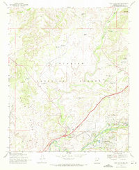
1969 Map of Lake Montezuma
USGS Topo · Published 1972About this map
Montezuma Castle National Monument and the adjacent Montezuma Well anchor the southeastern corner of this Yavapai County landscape, where the perennial flow of Beaver Creek meets a developing residential network. The late 1960s suburban expansion of Lake Montezuma is visible through a dense grid of named streets like Valley Vista Rd and Top-O-The Morning Dr, contrasting sharply with the expansive grazing lands of Beaverhead Flat.
Find a feature on this map
51 named features on this map. Tap any name to fly to it.
Don’t see what you’re looking for? This feature index may not catch every label — zoom into the map to look around manually.
Map Details
Editions of this 1969 Lake Montezuma Map
2 editions found
Other maps of this area

1887 · Verde
USGS Topo · 1:250,000

1892 · Verde
USGS Topo · 1:250,000

1923 · Camp Verde
USGS Topo · 1:125,000

1932 · Camp Verde
USGS Topo · 1:125,000

1936 · Camp Verde
USGS Topo · 1:125,000

1954 · Holbrook
USGS Topo · 1:250,000

1957 · Holbrook
USGS Topo · 1:250,000

1958 · Holbrook
USGS Topo · 1:250,000

1960 · Holbrook
USGS Topo · 1:250,000
1965 · Munds Mountain
USGS Topo · 1:24,000